
Benbulben is one of Ireland’s most distinctive mountains, surrounded by cliffs and ringed in mythology. This forest walk is a family friendly trail that gives you the best views you can get of this peak. With three different route options, you can go as far as you like, with get vantage points over to Donegal. The two highlight sections for me were the very northern corner for views of the cliffs, and the twisting trail through the southern edge of the mixed woodland.

Overview
Distance: 6km
Time: 1 - 2 hrs (depending on route and fitness)
Parking:
Car Park A: Main Car Park
Car Park B: Gortarowey Forst Car Park is new, and a great access point for Cashelbaun ringfort.Trail difficulty: Easy
Definition: The trails here are signposted, on easily identifiable paths, with good underfoot conditions. There is a multi-access trail from the main car park.
Learn more about how we assign trail and hillwalking grading in Ireland.Trail quality: 5/5
In terms of this being an accessible trail, the routes here are very well maintained and walkable by a wide variety of people. There is no road walking at all in this trail.Views: 4/5
This trail offers the best views you will find of Benbulben and its dramatic cliffs, as well as views towards Donegal and Slieve League.Buggy/Wheelchair friendly: Yes
There are some kissing gates throughout the trail, but on a whole the terrain is a well maintained gravel path.Dogs allowed: Yes
Dogs are allowed on these trails, as long as on a lead.Maps: Download the official Coillte map of the area here.
Other walks from the main trailhead: Yeats Trail (5km); Cashel Loop (4km); multi-access path (250m).
Related Links:
As I pull into the car park the light pitter-patter of raindrops hitting my windscreen begin to drown out the radio, and I cross my fingers as I park the car that this is just a passing shower. It’s June, and yet somehow summer still hasn’t arrived to Ireland. Looking up at the peak above me, I marvel at how amazing the view is from the car park. I’m sure for some, just pulling in here would be enough.
The Benbulben Forest Walk has existed for several years, but recently there has been new info-boards, car parking, and general infrastructure built along this route - which I can only assume is to account for the popularity of the views you get of Sligo’s most well known mountain. Part of the Dartry mountains, this area of the north-west is home to the only plateau mountains I’ve experienced in Ireland.
The route I’m following today is the full Forest Walk, coming in at around 6km. However, there are a few junctions that you can take along the way to shorten the trail, and each are well marked.
Heading out of the car park, I follow the trail north past the small cottage sitting under the mountain up a gentle incline. In general, I think this trail is widely accessible, and this first section has no restricting gates. The first point of interest is the Yeats Trail stop.
The Yeats Trail is a signposted touring route that links fourteen places in Sligo that were significant to the poet W.B. Yeats. I’ve been coming across the signage and installations for this trail for the past two years since moving to the north-west. At around 100km, this isn’t a walking route, but would certainly be a lovely driving or cycling adventure.
See the map of all the locations here, and learn more on the official website here. The website explains the trail as: “The traditions, stories and landscape of Sligo provided Yeats with the inspiration for some of his best loved poems. Artistic installations located along the route provide the visitor with a space in which they can enjoy and interpret the poems for themselves, while walking in the footsteps of Ireland’s national poet.”
This also feels like the right moment to highlight that The Yeats Trail, and many of the day walks I’ve done in Sligo, all incorporate the maps and artwork of Annie West, who brings the landscape to life in such a unique way that I really love.


After the Yeats Trail stop, the trail passes through a simple kissing gate and has a long open stretch, with forest to the left and the cliffs of the mountains drawing closer to the right. The forest slowly creeps towards the mountain slopes and after a few minutes of walking we enter under its shadowy branches.
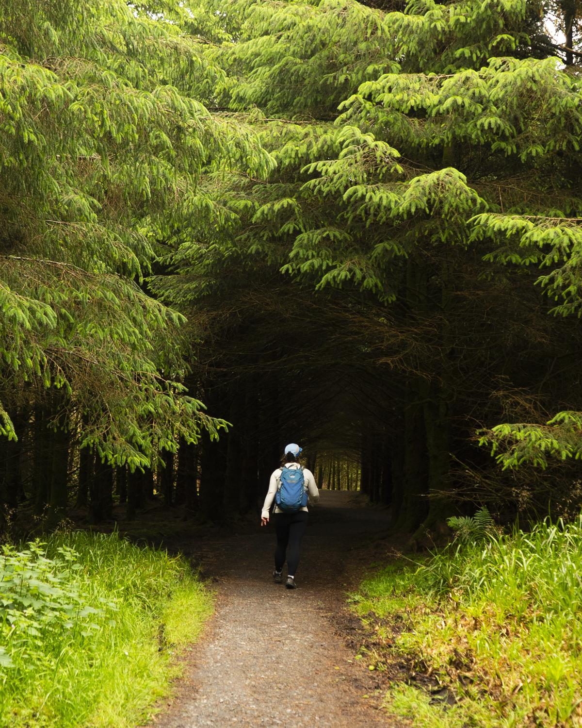

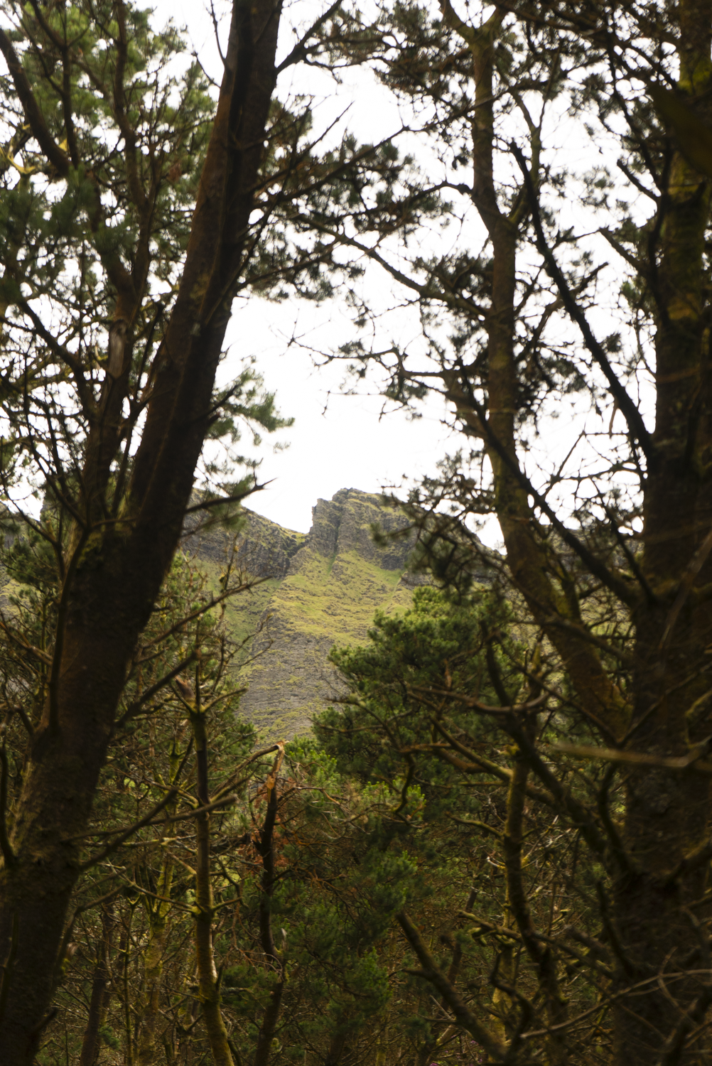

This section of shady paths gives us glimpses out to our surroundings, hinting at the views ahead. This section is mostly spruce, and the dark quiet almost feels eerie. But then the forest opens up ahead of us, revealing my favourite views of the trail.


At this most northerly section of the trail we have the best views of Benbulben’s ragged crags. Looking up at the wild walls and twisted trees, its no wonder that this area has so many connections to Irish mythology. The most widely known is the pursuit of Diarmuid and Gráinne, who in some stories lived in these mountains, in other stories merely spent the night in one of the highest caves. In most retellings, Diarmuid dies on a boar hunt here, and the mountain became his and Gráinne’s final resting place.


From here the trail turns south, the forest now somewhat behind us and the views of Donegal and Slieve League taking over. As I pass by the junctions back through the forest back to the east side of the forest, the trail becomes quieter. Descending some small hills, the track widens to more traditional forestry road, and eventually comes down to Gortarowey Forest Entrance, a newly developed car park and trail access point. There’s another info board and room for several cars. The trail cuts back in, and leads us up to Cashelbaun.
Cashelbaun in a ringfort from the early medieval period (c. 400 - 1100 AD). Following the small off-shoot path into the rings of the fort, the lines are easy to see where the walls would once have stood high. The silence of the area, views of the mountains, and wind off the sea, gives the place an ancient feel. As I stood inside the walls I could imagine the thousands of people to have passed along this path before me.
According to the small plaque, this ringfort has more than one enclosing element and a commanding view of the surrounding area, which indicates that it occupants had a high status in the local clan. An extended family would have lived here, their livestock kept within the confines of the fort for security during raids as cattle rustling was a problem at the time.


Leaving the ringfort behind, I follow the trail back towards Benbulben and into the forest.
This stretch was beautiful, twisting and turning around decaying logs and moss-covered branches. There’s a mixture of woodland growing here, with native oaks and ferns poking through. The vibrance of the greens, browns and oranges force me to appreciate the dampness of Ireland.
Something that is prevalent in the woodland is rhododendron, which is invasive in Ireland. It grows faster than our native plants, choking them of sunlight and out-competing them until the rhododendron completely takes over. However, as I make it back to the final section towards the car park once more, I come across sections where the rhododendron is being professionally removed to improve the biodiversity of the forest. It’s a slow job, but one I was heartened to see.
As I climbed the last bit of trail to the car, I feel like I’ve come to this trail at the perfect time - the infrastructure has been improved to provide a lovely day out, and the work is being put in to make this even better in the future.


Further exploring
Other trails in the area:
Mountain Hikes:
Favourite Local Coffee / Food Options:
Shells of Strandhill
Rover Coffee Lab, Sligo